Watershed Facts
Definition of a watershed
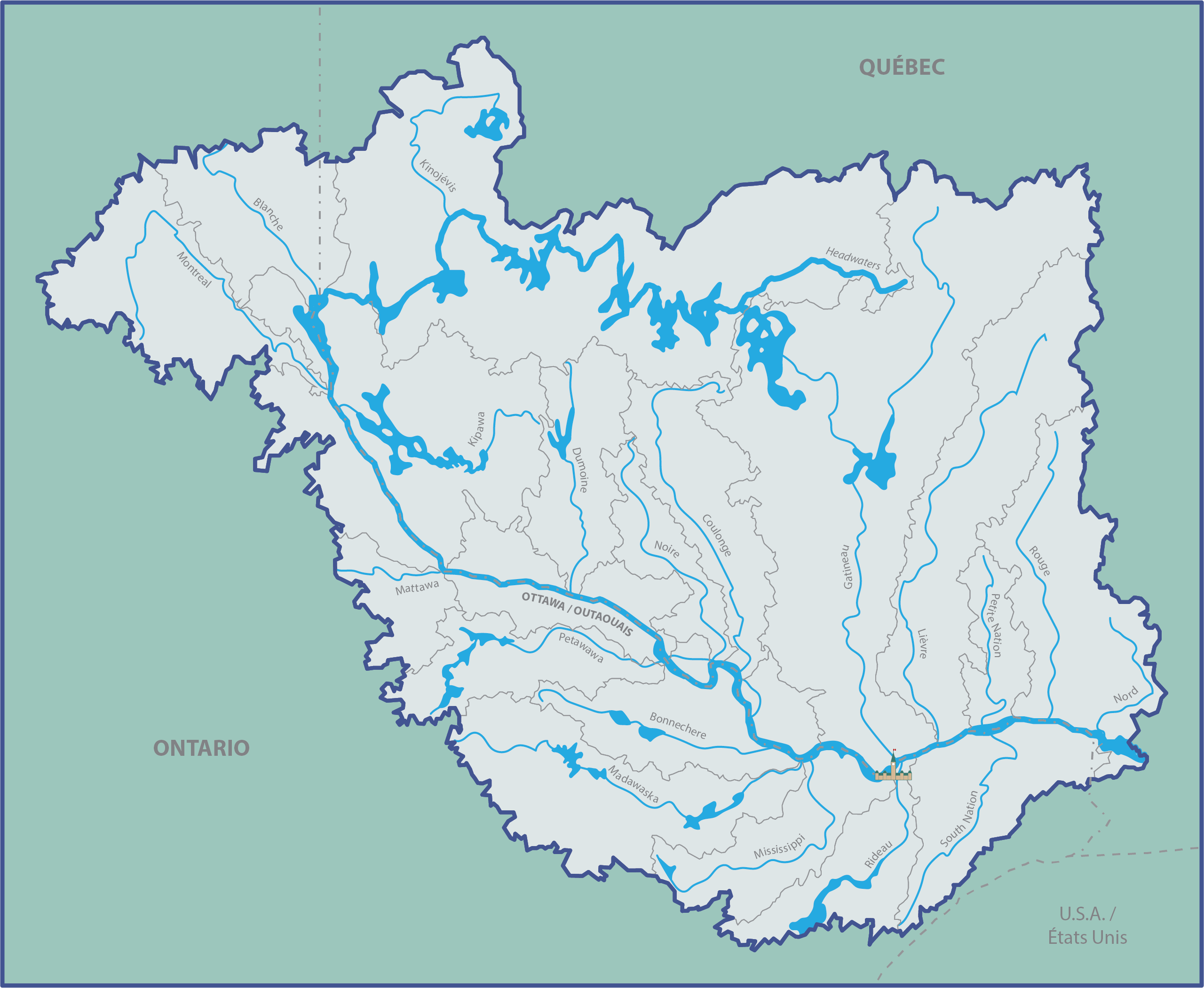
A watershed, sometimes called a catchment or drainage basin, is a physical boundary. It describes the area of land that drains to a single location. In other words, as rain falls onto the land the water will accumulate and move down slope towards creeks, rivers, ponds and lakes, and continue to move downstream towards the mouth of a river. Each creek, river, pond, and lake has a watershed. Each watershed is separated from neighbouring watersheds by points of high elevation. The Ottawa River is part of the St.Lawrence River watershed and is its largest tributary. Within the Ottawa River watershed, there are many smaller and smaller watersheds for each river and creek. For example, the Bonnechere, Dumoine, Gatineau and Rideau Rivers each have their own watersheds that are part of the Ottawa River watershed.
A watershed can contain many different types of land cover including forests, wetlands, waterbodies, developed areas, and agricultural lands. The land cover present in a watershed can impact the rivers present by affecting the how much and how quickly rainfall moves over the land, and if there are pollutants, nutrients, or sediment that might be transported to local streams and impact rivers water quality. Everything within a watershed is connected; what is done in one part of the watershed affects the other parts.
The Ottawa River watershed at a glance
Name Origin: The name ‘Ottawa’ is derived from the Anishinàbemowin (Algonquin language) word adàwe, meaning “to trade”. Historically, the Anishinabeg (Algonquin people) controlled the trade of the river and it was a primary highway through their territory. In Anishinàbemowin, the Ottawa River is known as the Kichi Sibi, which translates to the Great River or La Grande Rivière. The name Ottawa was first applied to the river, and then to the city. The French word is Outaouais.
Source: Lac des Outaouais (QC): located 250 km north from Ottawa and 290 km northwest from Montreal in the Administrative Region of Outaouais. The nearest facility is Clova, a former forestry village that’s now serving several outfitters’ lodges. Clova is also a station of the Abitibi railway (ViaRail).
Length: 1,271 km (from source to mouth)
Loss of elevation: The river descends approximately 400m from an elevation of 430m at the headwaters to 20m at its mouth.
Flow as measured at Carillon Dam: Average daily flow: 1,950 m3/s, Historic daily minimum: 306 m3/sec in 1971, and Maximum daily flow: 9217 m3/sec in 2019
Area of drainage basin (watershed): 146,300 km2. Stretches from Shining Tree in the west to St. Jerome in the east; from Westport in the south to Launay in the north; from Algonquin to Aiguebelle, from Temiscaming to Tremblay. It is twice the size of New Brunswick and larger than many countries, including Greece, Portugal, Switzerland, England, Scotland, Bulgaria, Cuba, and Denmark.
Elevation extremes: Quebec: Pic Johannsen (935 m). Ontario: Ishpatina (693m).
Terrestrial Ecozones: Boreal Shields and Mixedwood Plains
Geography & Geology
A glance at a satellite image will immediately illustrate that the Ottawa River is one of the great rivers of the continent. The second largest river in eastern Canada, it extends 1271 km (780 miles) with a 140,000 km2 (34,600,000 acres) watershed.

Most of the river is located within the Canadian Shield, the continent-spanning highland underlain by Precambrian age bedrock, that supports hundreds of thousands of lakes and constitutes the world’s greatest concentration of freshwater. This predominantly acidic and erosion-resistant substrate sustains vast areas of forested land, that are essential to the quality and continuity of freshwater production across Canada. From across this globally significant reservoir flow great rivers of immense ecological and economic importance, such as the St. Lawrence, the Saguenay, the Nelson, the Eastmain, the Churchill … and the Ottawa. The volume of water in the Ottawa River is equivalent to the volume of water in all of western Europe.
- Geoheritage of the Ottawa River
- Paleontological Highlights of the Ottawa River
- Maps of the Ottawa River watershed
Human Impacts on the Ottawa River
Given the vast size of the Ottawa River Watershed and the number of people who live here, it is no surprise that the river is under pressure from many different activities. Given our dependence on our natural resources these pressures will always be real. However, if we are to preserve and protect the ecological health of our river system, we must begin to understand and predict what the cumulative impacts of our actions are and find solutions that enable our future generations to safely eat fish and drink water from the river.
Currently, there is no understanding of the total loading of pollutants to the river system from known sources such as municipal and industrial wastewater, let alone from non-point sources such as urban stormwater, agriculture runoff or boating. In addition, there is limited understanding of how the river operates as a system – how the river is shaping itself, responding to the presence of many dams, and increasing impervious areas or resource extraction (forestry, mining) for example. Our baseline data is sparse at best. As an inter-provincial river, these issues are not fully addressed by either province on its banks in terms of a comprehensive watershed study.
The major watershed-scale pressures that are currently threatening the ecological health of the river are:
- Dams
- Municipal Wastewater
- Industrial Wastewater
- Urban Stormwater
- Agriculture
- Floodplain and Shoreline Development
- Wetland Destruction
Parks within the watershed
Ontario: Lake Evelyn Smoothwater Provincial Park, Larder River Provincial Park, Mattawa River Provincial Park, Samuel de Champlain Provincial Park, Westmeath Provincial Park, Ottawa River Provincial Park, Algonquin Provincial Park, Upper Madawaska River Provincial Park, Lower Madawaska River Provincial Park, Lake St. Peter Provincial Park, Driftwood Provincial Park, Fitzroy Provincial Park, Bon Echo Provincial Park, Sharbot Lake Provincial Park, Rideau River Provincial Park, Silver Lake Provincial Park, Voyager Provincial Park and Murphy’s Point Provincial Park.
Quebec: Gatineau Park (NCC), Mont-Tremblant Québécois Park, d’Aiguebelle Québécois Park, Oka Québécois Park, Plaisance Québécois Park, La Vérendrye Québécois Wildlife Reserve, Papineau–Labelle Québécois Wildlife Reserve, Rouge–Matawin Québécois Wildlife Reserve and Opémican National Park.
Major tributaries
Upper Ottawa River: Camachigama, Capitachouane, Chochouane, Darlens, Kinojévis, Blanquet and Wabi Creek.
From Lake Temiscaming to the mouth: Kipawa, Montreal, Mattawa (43 km), Petawawa (187 km), Bonnechere (145 km), Madawaska (230 km), Mississippi (169 km), Rideau (146 km), South Nation (161 km), Rigaud, Maganasipi, Dumoine (129 km), Noire, Coulonge (217 km), Gatineau (386 km), du Liévre (330 km), Blanche, Petit Nation (97 km) and Rouge (185 km).
Largest Islands: Isle-aux-Allumettes, Ile-du-Grand-Calumet, and Kettle Island
The Ottawa River is connected to: Lake Ontario by the Rideau Canal system and with the Upper Gatineau River by the diversion from the Cabonga Reservoir in the Gatineau River basin to the Dozois Reservoir (situated in the headwaters of the Ottawa River) through the Barrière dam. The Cabonga-Dozois diversion is opened in order to assure a minimum flow to satisfy the needs of hydroelectric production on the upper Ottawa River. The Mattawa River is a natural passage through the Algonquin Highlands between Lake Nipissing and the Ottawa River. It rises 3.5 km east of Lake Nipissing and flows east along an ancient fault line into the Ottawa River. At one point, the Mattawa River connected Lakes Superior and Huron to the Ottawa River.
Ecological Significance: The Ottawa River Valley is home to at least 24 provincially or nationally imperilled species, including Least Bittern, Spotted Turtle, and American Ginseng. Its microclimate, sand, and limestone substrate sustain rich wetland and forest habitats that support a diversity of flora and fauna. While the region is one of the most threatened landscapes in Canada, it hosts the most biologically diverse ecosystems in Québec. (Source: The Nature Conservancy)
The Ottawa River is also home to a unique and diverse fauna of freshwater mussels. This unique freshwater mussel fauna includes a minimum of 14 different species (27 % of the Canadian freshwater mussel fauna), each one linked to specific fish hosts which ensure the upstream and downstream dispersal of the mussel’s specialized glochidia larvae. In many areas of the Ottawa River, the density of freshwater mussels on the bottom commonly exceeds 100 individuals per square metre. This is a very high value compared to other rivers in Eastern Canada. (Source: André Martel – Canadian Museum of Nature)