Posted: June 11, 2019
6 things you should know about the 2019 Flooding
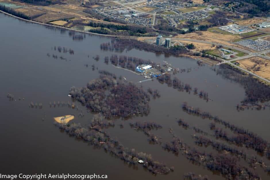
There has been a lot of talk about how much water was in our watershed this year. But where did it all come from? How has this contributed to the flooding?
1) There was a lot of snow on the ground late into the year
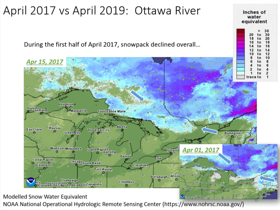
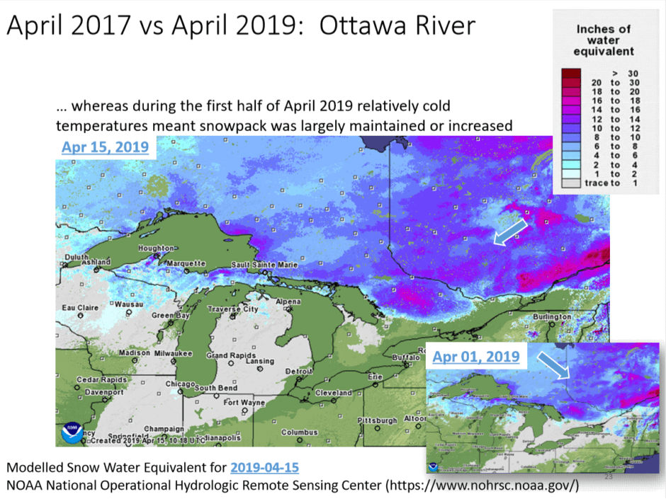
One difference between 2017 – when we saw significant flooding in many parts of the watershed – and 2019 is the rate at which the snow melted. In April 2017 the snowpack declined throughout the month, but in 2019 the cold weather persisted, leaving more snowpack on the ground. When the snow began to melt later in April, there was far more water entering the river system than is normal.
The slides below (from Environment and Climate Change Canada) illustrate the levels of snow in the watershed at the beginning and middle of April in both 2017 and 2019.
2) The amount of rain contributed to the water levels
In 2017, the flooding was attributed to the heavy rains. Once again, 2019 was a year that saw incredible levels of precipitation in our watershed. Both 2017 and 2019 saw exceptionally rainy months of April. While the rain was less intense this year, its quantity – compounded with the extra snowpack – meant that we saw large amounts of runoff causing water levels to rise quickly as the water entered the river system.
3) There are reservoirs in the watershed, but…
There have been a lot of questions about the reservoirs in the watershed, and how they work to hold back the spring freshet. In the Ottawa River watershed most of the reservoir dams on the Ottawa River are in the northern part of the watershed; those with significant reservoir capacity are all located at or upstream of Témiskaming. Every year, these reservoirs are emptied in early spring to make room for the spring melt. This allows for the spring freshet from this northern part of the watershed to be held back as long as possible.
Since the central and lower parts of the watershed have minimal reservoir capacity, there are no additional mechanisms in place to control the water levels in these regions. As each subwatersheds’ snowpack melts, this adds to the volume of water reaching the Ottawa River. With heavy rainfall , as experienced in 2017 and again in 2019, this significantly increases water levels as the rain mostly runs off the snow and frozen land. This year, the late spring run off contributed to the very slow decline in water levels.
4) Flooding is caused – and influenced by – a multitude of factors
Flooding is a natural part of river systems; all rivers flood, to varying degrees, most years. The severity of these floods changes from year to year. As you can see above, 2019 saw significant amounts of snowpack and rain enter the watershed, which was one of the contributing factors to this year’s floods.
The impact of flooding can also be altered by human activity. Development on wetlands, removal of forests, altering riparian zones and development in general can all impact how water moves through a watershed.
While flooding is a natural process, understanding how our actions impact the severity of such events can be challenging but important to understand. It is rarely one factor that leads to the catastrophic experienced in our watershed this year, and it will take time and resources to understand what steps can be taken to better prepare for and possibly mitigate severe flooding in the future. Any investigation into the flooding this year should explore all of these many factors.
5) How to dispose of sandbags
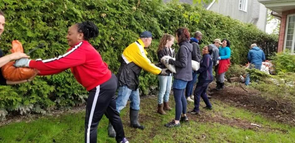
If you have sandbags and want to dispose of them, make sure to check the information published by your city / municipality / town. The best place to start looking for this is online as many jurisdictions published ‘2019 flooding’ resource pages on their website.
Sandbags and sand used for flood protection can be re-used in a few ways, but caution must be taken. The sand that has come in contact with flood waters may be contaminated, and should not be used unless first made safe. Avoid using this sand for playgrounds, sandboxes or other areas that might lead to direct human contact. Municipalities are using sand differently. For example, some are using it as a cover for their dumps and while others will be saving this sand to use as grit in the winter. If you are storing sand or sandbags, make sure they are carefully dried out, as mold can be a real problem if improperly stored. Get more tips on how to use this sand safely from the Rideau Valley Conservation Authority here.
However, sand from sandbags should not be added to the river or within the littoral zone, which would allow that sand to move easily into the river. Adding sand to shorelines or the river, especially in large quantities, can have a negative impact on the river ecology and could be detrimental to sensitive aquatic environments. The sand would disrupt the balance of sediment flow within the river, as opposed to the natural sediment movement that happens during a flood.
6) Ottawa Riverkeeper does not control or monitor water levels
During this year’s flooding we saw a surprising amount of confusion about what we do! We are a charitable organization that helps to protect the ecological health of the Ottawa River. We work to raise awareness about issues affecting the river, and develop initiatives to tackle them. During the flooding, we provided resources and shared information from a variety of sources. We do not have any control over water levels in the Ottawa River and its tributaries.
Our initiatives and programs include:
- Our Riverwatch program, which recruits citizen scientists to monitor water quality and other watershed health indicators
- Advocating for the protection of endangered species, such as the American eel
- Managing a Pollution Hotline, where citizens can call to report pollution or other suspicious activity on the river or shoreline
- Organizing shoreline cleanups with community volunteers
- Our Youth Water Leaders Program to engage youth in the protection and promotion of our watershed
- A learning library where groups and individuals can borrow educational activities and materials
Recently, we received $275,000 in funding from Environment and Climate Change Canada to expand our citizen science initiatives, helping us measure new indicators and better understand the ecological health of the Ottawa River watershed. This funding is to support the continuation of work started last year on watershed health indicators, and is not related to this year’s flooding, nor is it meant to work towards the prevention of future flooding. The data collected by this program will be made publicly available, and will help us bridge gaps in our understanding of the state of the watershed.
So who does work with water levels? During the spring the Ottawa River Regulating Committee coordinates the dams and reservoirs in the watershed to prevent and mitigate flooding. This committee report to the Ottawa River Regulation and Planning Board. If you want more information on floods and water levels in the watershed, they have some great resources on their website, and also a “contact us” page where you can make further inquiries!
A lot of this is BS!! We’ve had higher snow levels in years with no flooding. We’ve had higher spring precipitation rates with no flooding. 2019 and 2017 had higher than ‘normal’ water levels in the fall, before the Ottawa River froze over and we had flooding?! Human inaction or incompetence played a large roll in this years flood!
Hi Pete. As we mention in the blog, floods like these are caused by a combination of multiple factors. Yes we have had years with higher snow level, and years with more rain. However we have rarely seen them together in the same year like this, and additional factors such as the low temperatures late into the spring also contributed. While we have large reservoirs in the watershed, those with significant storage capacity are all in the northern part of the watershed. These reservoirs were emptied in March as they are every year to make room for the spring freshet. However, they are not able to store water that came from the middle and southern areas of the watershed, much of which comes from a number of major tributaries, which contributed significant volumes of water to the Ottawa River this spring.
What standards of accountability do you follow when spending donated money and public moneys? How do you measure and show effective utilization of your funding?
Hello Bill, you can find out more about our funding on our financials page, and by reading our Annual Reports.
The report talks about the unusual rains, unusual snow pack, the unusual temperature patterns, but nowhere does the phrase “climate change” get mentioned. We look to you for leadership.
Until our leaders call it what it is – “climate change”, there will be no action to correct it. I’m disheartened by your avoiding of the phrase.
Even the City has declared a climate emergency. Ottawa has had tornadoes in the past 2 years. We’ve had these hundred-year floods in 2 of the last 3 years. We need the Riverkeeper to lead and call this what it is – climate change
Hello George, thanks for your message. We re-read our blog, and you’re right, we could have used the phrase “climate change” specifically. We have certainly mentioned it elsewhere publicly when discussing this year’s flooding, such as in this CBC article. As we stated in that article, pointing to a single factor as the cause of the flooding can sometimes overshadow the many other contributing factors. That’s why we are advocating that the inquiry many are calling for have a broad mandate, including looking at climate change and factors such as land-use and shoreline management, rather than be focused on a single issue like dam management.
I saw an interview on the Business News Network (BNN), where the Canadian insurance industry has just issued a report on the insurance costs of the floods of 2017 and 2019. The interviewee (who might have been the author of the report) had graphs showing the costs of these disasters is skyrocketing. Yet the phrase “climate change” did not pass his lips.
What’s going on here? We can’t fix something if we are afraid to even say it’s name!
We need to also look at the human health (physical and emotional) impacts of these events. There is a coming together of community which is a benefit but much is also lost the impact of which we have yet to understand
Why wasn’t the water taken down during February and March by at least a metre
Or two seeing we had so much snow ,that way the system would recover and help
prevent flooding to this magnitude.
In an inquiry in Westmeath it was stated
that the system was capable of holding
two spring floods.in 1979